


Share
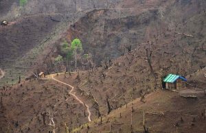 A file picture of a ‘jhum’ field in Kohima district.[/caption]
Kohima Bureau
Kohima, April 9 (EMN): The extensive practice of 'jhum' cultivation (or ‘shifting cultivation’) in the hills of Nagaland results in the average loss of 30.62 metric tonnes of soil area per hectare annually, according to a government report.
In its annual report of 2017-18, the state’s department of Soil and Water Conservation has reported that said average loss of land area comes in the form of “turbulent velocity of runoff and soil erosion.”
This further leads to destruction of prime agricultural and forest lands in the form of erosion, landslides, flash floods and sedimentation – the report has observed.
Being one of the major means of land uses in the state, the report stated, the practice of shifting cultivation involved 1,35,339 rural households covering about 947.37 sq km. This in turn constitutes 5.71% of the state’s total geographical area, according to the department’s report.
The traditional style of jhum cultivation using a ‘vast area’ leads to soil degradation which ultimately affects ‘production and productivity of the land’, the report stated.
In agriculture, Nagaland is still considered one of the most backward states ‘with low productivity and poor in livestock production’. The states’ topography is divided into hill ranges which further breaks into spurs and ridges. High rainfall during the monsoon, it stated, leaves the state very vulnerable to heavy runoff and soil erosion.
Even as the state’s economy is closely linked to its natural resource base and climate sensitive sectors such as agriculture and forestry, it has been left facing what the department said was an increased risk of the negative impacts of climate change.
Thus, according to the department’s judgement, ‘land development for economic cultivation is a huge challenge under prevailing conditions’.
Another problem, according to the report, was the state’s record of high annual rainfall – characterised by excessive surface runoff during summer and drought like situation in winter. Though the report noted that the state’s annual rainfall varies from 150 cm to 220 cm which could be a blessing if harnessed to the optimum, it becomes a problem under the prevailing topography and system of land use in the state.
Excessive rain causes high erosive velocity of surface runoff which in turn results in the washing away of fertile top soil and inundation of streams and rivers. As a consequence, it reduces the productivity of the land and hampers the recharge of ground water as well, the report stated.
It further remarked that Nagaland is highly prone to multiple hazards as it falls under seismic zone V and is very susceptible to landslides. About 15,551 sq km of the state’s geographical area is said to be under ‘landslide zone’. Earthquake is also one of the major disasters which have been striking this region (small scale tremors) in recent times.
Although the department has not cited any specific reasons, it maintained that cases of fire-incident have been reported frequently from all parts of the state.
While identifying those problems and challenges, the department however asserted that its endeavour was ‘to bring about sustainable development in harmony with nature through optimum development and judicious utilisation of natural resources’.
According to the report, the department was stated to be ‘taking up broad-based conservation activation through various state and centrally sponsored schemes throughout the state’.
A file picture of a ‘jhum’ field in Kohima district.[/caption]
Kohima Bureau
Kohima, April 9 (EMN): The extensive practice of 'jhum' cultivation (or ‘shifting cultivation’) in the hills of Nagaland results in the average loss of 30.62 metric tonnes of soil area per hectare annually, according to a government report.
In its annual report of 2017-18, the state’s department of Soil and Water Conservation has reported that said average loss of land area comes in the form of “turbulent velocity of runoff and soil erosion.”
This further leads to destruction of prime agricultural and forest lands in the form of erosion, landslides, flash floods and sedimentation – the report has observed.
Being one of the major means of land uses in the state, the report stated, the practice of shifting cultivation involved 1,35,339 rural households covering about 947.37 sq km. This in turn constitutes 5.71% of the state’s total geographical area, according to the department’s report.
The traditional style of jhum cultivation using a ‘vast area’ leads to soil degradation which ultimately affects ‘production and productivity of the land’, the report stated.
In agriculture, Nagaland is still considered one of the most backward states ‘with low productivity and poor in livestock production’. The states’ topography is divided into hill ranges which further breaks into spurs and ridges. High rainfall during the monsoon, it stated, leaves the state very vulnerable to heavy runoff and soil erosion.
Even as the state’s economy is closely linked to its natural resource base and climate sensitive sectors such as agriculture and forestry, it has been left facing what the department said was an increased risk of the negative impacts of climate change.
Thus, according to the department’s judgement, ‘land development for economic cultivation is a huge challenge under prevailing conditions’.
Another problem, according to the report, was the state’s record of high annual rainfall – characterised by excessive surface runoff during summer and drought like situation in winter. Though the report noted that the state’s annual rainfall varies from 150 cm to 220 cm which could be a blessing if harnessed to the optimum, it becomes a problem under the prevailing topography and system of land use in the state.
Excessive rain causes high erosive velocity of surface runoff which in turn results in the washing away of fertile top soil and inundation of streams and rivers. As a consequence, it reduces the productivity of the land and hampers the recharge of ground water as well, the report stated.
It further remarked that Nagaland is highly prone to multiple hazards as it falls under seismic zone V and is very susceptible to landslides. About 15,551 sq km of the state’s geographical area is said to be under ‘landslide zone’. Earthquake is also one of the major disasters which have been striking this region (small scale tremors) in recent times.
Although the department has not cited any specific reasons, it maintained that cases of fire-incident have been reported frequently from all parts of the state.
While identifying those problems and challenges, the department however asserted that its endeavour was ‘to bring about sustainable development in harmony with nature through optimum development and judicious utilisation of natural resources’.
According to the report, the department was stated to be ‘taking up broad-based conservation activation through various state and centrally sponsored schemes throughout the state’.