Eastern Mirror Desk
Dimapur, Sep. 26: A reporting agency of the government says that Nagaland has experienced a decrease of 450 sq km of forest cover. The reason for the decrease in forest cover is attributed to shifting cultivation and ‘developmental activities.’ This was revealed in Nagaland Forest Survey Report 2017.
Based on interpretation of satellite data pertaining to Oct.-Dec. 2015, the forest cover in Nagaland is 12,489 sq. km, which is 75.33% of the state’s geographical area. In terms of forest canopy density classes, the state has 1,279 sq km under ‘very dense forest’ category, 4,587 sq km ‘under moderately dense forest’ category and 6,623 sq km under ‘open forest.’
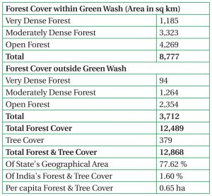
According to a Press Information Bureau (PIB) report, the state has reported a recorded forest area of 8,623 sq km amounting to 52.01% of its geographical area. The Reserved and Unclassed Forests are 2.71% and 97.29% respectively of the recorded forest area. Due to unavailability of digitised boundary of recorded forest areas of the state, the updated green wash area, which is 10,672 sq km, has been used. The forest cover within and outside this area:
The total Carbon stock of forests in the state is said to be 125.060 million tonnes (459.553 million tonnes of CO, equivalent) which is 1.76% of total forest carbon of the country.
An increase of 23 sq km has been observed in the water body coverage within forest compared to 2005. In 2005 the water body coverage within the forest was 40 sq km and in 2015 there has been an increase of 63 sq km extent of water bodies.